Planetary engine that can be used with real elevation data of arbitrary resolution, while being progressively enhanced by fractal algorithms. The fractal algorithms refine and introduce details down to centimeter resolution and can be parametrized by elevation and land class data. A completely random fractal terrain is possible too, or a terrain can be sketched in rough resolution with fractal generating the details. Level of detail ranges from thousands of kilometers down to centimeters, with full visibility. The engine is fully asynchronous, majority of the algorithms running on the GPU while the rest is distributed to multiple CPU cores.


Banked roads support
Post a comment
Description
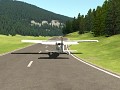
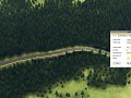
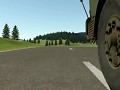
Video showing road editor with recently added support for banking.
great tech with the roads, will they offer more traction the further you work on this? or are the roads just for aesthetic purposes?
Yes, surface material info will be used in wheel physics simulation.
Laughed when I shown how much sloped the road is and then took a Tatra to it :D
Amazing as always.
Can you make the road tool automatically fix the slope as you confirm the route?
would be a pain to hitchhike those...