• Register

Game about sea war. One ship, two torpedoes and many enemies is this to you. Period presentation in the game - WW2 1940- 1944 years. The main figure in game is the submarine, a certain class, and the opponent the German military and partially merchant marine fleet appears. The player should heat cargo vessels, to leave from the military ships, to disappear from ubiquitous air reconnaissance, to avoid anti-submarine systems and much, many other. In spite of the fact that actions are planned generally guerrilla, it is supposed that it isn't necessary to miss. In difference from known Silent Hunter, the player shouldn't squeeze time as soon as possible to reach a patrol square, it is connected to that actions are planned by more dynamic, and the active. With impunity nobody will allow to plow a water smooth surface in a surfaced state to the player. The player with enviable periodicity will change a role from the hunter to a game and back.

Post news Report RSS New terrain - new map!

The system of navigation received long-awaited up-dating. Our boat is transferred to a new place of a dislocation. Boundaries of a land are significantly adjusted, having received likeness to real outlines of real coast. The general view of the earth received a big share of additions and updates.

Posted by on

In game there were following changes. Earlier, the boat passed tests for the territories of the deep-water lake, but its sizes didn't allow to make optimum testing. Now the boat is transferred to the sea. Testing on the long route showed a row of shortcomings and problems the majority from which by this time is corrected.
As open spaces repeatedly increased, there was need for explaining the ground, to twist if far to departure - coast it isn't visible. In this regard, in game the navigation system is added.
The system of navigation consists while of two bases. It is a card and a compass. The card displays the sea and a point where now there is a boat, and the compass shows the movement direction. But it not all. Will be added as navigation beacons and markers of points of assignment. As friendly ports will be marked. Unfortunately, the card can't change scale, but even without such opportunity orientation isn't a problem. Everything is simple and available!

new terrain and new map

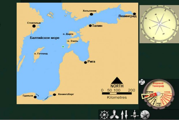
As there are also simply pleasant changes. The land starts taking more nice form. The part of the mains the island, and part of boundary of a land of the continent is at present already ready. Some regions received real depths. In the future all territory of the sea will have real depths, and a land whenever possible real height above sea level. As also the general appearance changed.

new terrain and new map new terrain and new map

Post comment Comments
Insolent.
Insolent. - - 669 comments

Looking good! The new navigation system should make it easier to get around, and is important once you get away from the shore and have no reference points.

Reply Good karma Bad karma+1 vote
bedndarc Author
bedndarc - - 33 comments

Yes, it is its purpose. :)

Reply Good karma+1 vote
Post a comment

Your comment will be anonymous unless you join the community. Or sign in with your social account: